Sorry, you need to enable JavaScript to visit this website.

Search

Revealing Subsalt Structure Using RTM 3D Dip Gathers

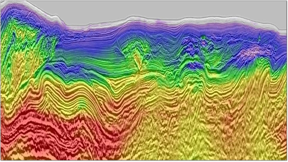
Gulf of Mexico (GOM) subsalt imaging often suffers from poor illumination due to salt-related wavefield distortion, even with full-azimuth (FAZ) acquisition. In order to image the weakly illuminated subsalt plays, isolating the signal from the noise is a crucial component of many depth imaging practices. Reverse Time Migration (RTM) subsurface 3D dip-azimuth gathers, which separate seismic data into different dip/azimuth components, have been utilized to address illumination problems in structure-oriented imaging techniques. We proposed a weighting scheme on RTM 3D dip gathers for imaging enhancement based on a priori structure information targeting the noise which has conflicting dips with the structure. We further discussed and evaluated the sensitivity of the method to the uncertainty of the priori structure dipping information. We applied the method on subsalt structures on a synthetic data set and a real data set with staggered acquisition full azimuth data. The tests demonstrated the necessity of signal-to-noise ratio enhancement in the imaging of FAZ, long-offset data and the effectiveness of RTM 3D dip gathers in unmasking poorly illuminated zones.
Download Resource

Fullband Imaging

In this article, we focus on variable-depth streamer acquisition and propose a full broadband processing solution that involves three important components: (a) 3D deghosting; (b) Q estimation using Q-Tomography; (c) Q application via Q pre-stack depth migration (Q-PSDM).

Download Resource

Multidimensional simultaneous random plus erratic noise attenuation and interpolation for seismic data by Joint Low-Rank and Sparse Inversion

We present an efficient convex optimization strategy enabling the simultaneous attenuation of random and erratic noise with interpolation in pre-stack seismic data. For a particular analysis window, frequency slice spatial data can be reorganized into a block Toeplitz matrix with Toeplitz blocks in the spirit of Cadzow / Singular Spectrum Analysis (SSA) methods. The signal and erratic noise are respectively modeled as low-rank and sparse components of this matrix, then a Joint Low-Rank and Sparse Inversion (JLRSI) enables us to recover the low-rank signal component from noisy and incomplete data thanks to a joint minimization of a nuclear norm term and a L1 norm term. The convex optimization framework, related to recent developments in the field of compressed sensing, enables the formulation of a well-posed problem as well as the use of state-of-the-art algorithms. We suggest here an Alternating Directions Method of Multipliers (ADMM) scheme associated to an efficient singular value thresholding kernel. Numerical results on field data illustrate the effectiveness of the JLRSI approach at recovering missing data and increasing the signal-to-noise ratio.

Download Resource

Targeting oil and gas in the Perth Basin using an airborne gravity gradiometer

Recently there has been renewed interest in the hydrocarbon potential of the Perth Basin in Western Australia. Recent discoveries of gas have shown that there is a working hydrocarbon system within at least the northern and central parts of the basin. In most parts of the basin, modern seismic data is relatively scarce. In the current low oil price environment, explorers are looking for cost-effective ways of exploring and targeting seismic acquisition. Airborne gravity gradiometry is such a technique. It has been widely used in frontier basins to understand the basin architecture, sedimentary structure and planning of seismic acquisition.

Download Resource

Wave equation based image warping

In seismic processing and reservoir characterization we often need to measure relative displacements between different realizations of data. Over the years many methods have been developed utilizing different similarity measuring techniques. Such alignment or warping methods are often effective signal or image processing tools. However, a survey of available methods shows that none are directly driven by the physics of seismic imaging. We show that a seismic image can be considered a field governed by the wave equation. We visualize different image realizations as snapshots of the wavefield at different times, and these give us the required displacements or time-shifts. By formulating the problem in a physical context, displacement vectors are obtained that honor the directionality of the wave propagation. For example, 4D time-shifts are obtained in a direction normal to the reflectors. We compute these shifts in an inverted finite-difference scheme. To overcome limitations of the two-way wave equation, we factorize it to its one-way counterparts. The method is demonstrated on synthetic and real datasets.

Download Resource

Broad bandwidths reveal double the expected sediment depth in the Northern Carnarvon Basin

Initial imaging results are deeper and clearer than have been seen in this area before, with enhanced imaging of the Triassic to Lower Cretaceous reservoir units. In addition to demonstrating that there is at least 20km of sediment in this area, clear faulting and structure of the deep layers can be seen, demonstrating the exceptional penetration power of broadband low-frequency seismic data.

Download Resource
Share Link
LinkedIn icon Facebook icon Twitter icon