


Regia 3D Marine Seismic Survey Information
CGG Services (Australia) Pty Ltd (ABN 70 081 777 755) is preparing an environment plan for its Regia 3D Marine Seismic Survey (MSS), located in the Otway Basin. The purpose of the Regia 3D MSS is to collect high-quality geophysical data about rock formations and structures beneath the seabed and assess potential for new oil and gas discoveries.
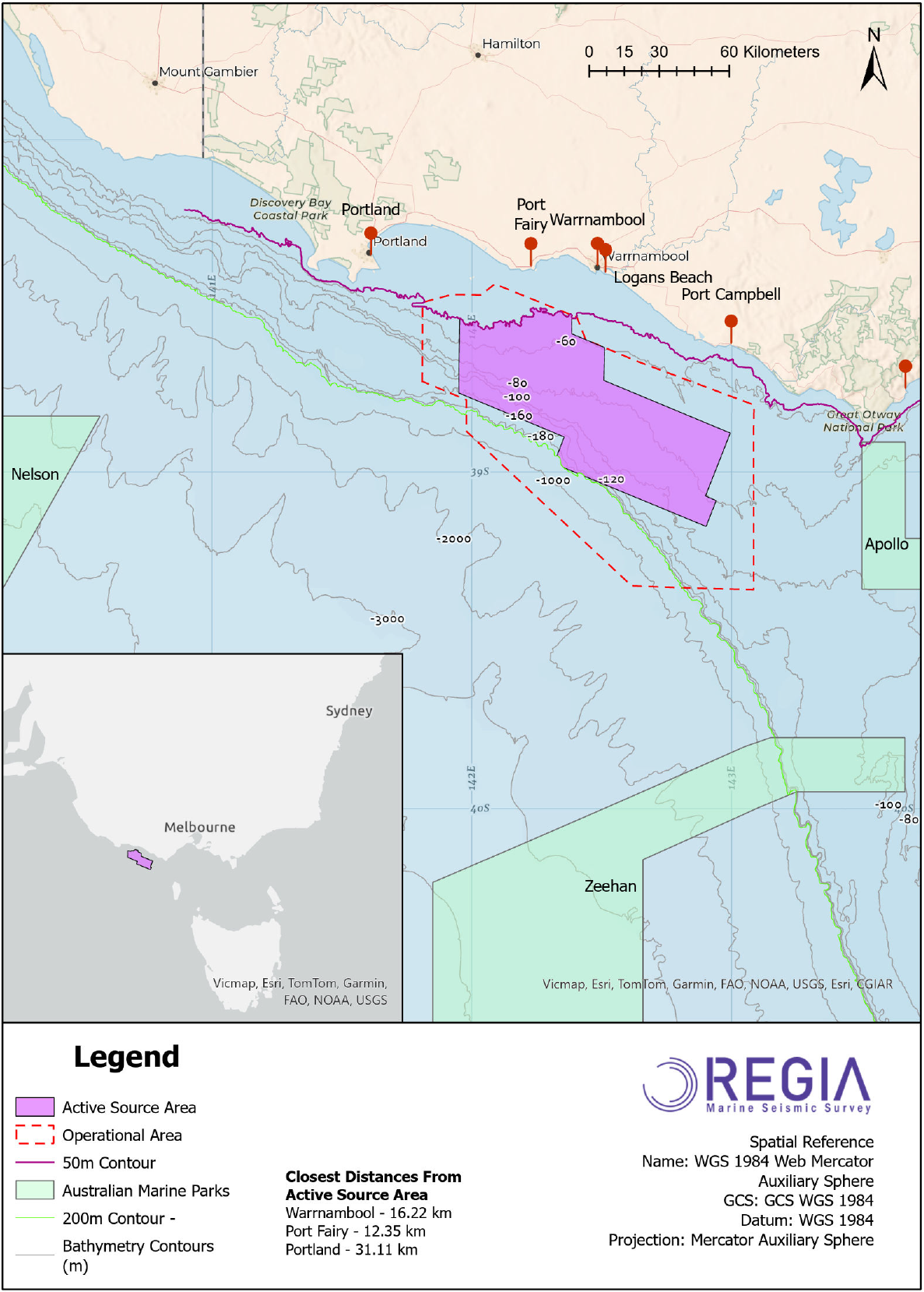
The Regia 3D MSS is a typical 3D survey using methods and procedures like others conducted in Australian waters. No unique or unusual equipment or operations are proposed. The active source area comprises the area within which 3D seismic acquisition will be undertaken and has a maximum sail line distance of 1,700 km. The active source area is surrounded by a larger operational area (approximately 4,000 km2), for the purpose of line turns, run-ins, run-outs, seismic testing, and support activities. The operational area at its closest is approximately 12 km south of Port Fairy. The seismic survey will be undertaken in water depths no shallower than 50 m, and no deeper than 200 m.
The survey will involve a single seismic survey vessel towing a seismic source array with a total volume of 2,820 cubic inches, at a water depth of between 5 - 10 m. The seismic source will use compressed air to emit regular pulses of sound that reflect off the seabed and underlying rock formations. The reflected sound wave will be received by up to 14 hydrophone streamers. Each streamer will be up to 8,100 m in length, spaced approximately 100 m apart and towed at a depth of approximately 25 m. During the survey, the seismic survey vessel will travel at a speed of approximately 4.5 knots, discharging the seismic source approximately every 12.5 m. The survey vessel will typically acquire seismic data along a series of adjacent and parallel lines in a “racetrack” pattern. When the vessel completes the line, it will turn again to follow another line offset approximately 500 m from the first. This pattern is repeated until the required coverage is completed.
The Regia 3D MSS will take a maximum of 90 days to acquire, and may be undertaken in any month except January, February, and March. The precise timing of the survey is subject to vessel availability, weather conditions and other operational considerations, and will consider the seasonality of environmental sensitivities, where practicable.
Further information about the activity, the environmental assessment process, and the consultation process can be found at regiamss.com.au.
There is also a video guide on how to navigate the Environment Plan.
CGG wishes to consult with relevant stakeholders to identify any functions, interests or activities that may be affected by the proposed operations.
The environmental consultant Klarite is engaging with stakeholders (local communities, Traditional Owners, fisheries representatives, conservation associations, regulatory bodies etc.) and addressing their potential concerns.
This page provides detailed information about the Regia 3D MSS:
1. Who is CGG Australia?
2. What is ‘multi-client data’?
3. What kind of activities are planned to be conducted during the Regia 3D Marine Seismic Survey?
4. Why is new data needed in this area?
5. How are seismic surveys authorized?
6. Do CGG activities impact the environment?
7. Is there a potential impact on fish?
8. Will this survey mean all fishing in the area will have to be stopped during acquisition?
9. What kind of consultation process has there been with the local stakeholders?
1. Who is CGG Australia?
CGG has had offices in Australia since 1983 and currently employs 23 people, in Perth. A leader in cutting-edge geoscience, we have a strong focus on innovation and a commitment to delivering the best sustainable solutions to our clients' energy challenges. We bring our clients a unique range of technologies, services and equipment designed to acquire extremely precise data and images of the Earth's subsurface. We also provide state-of-the-art software and services for analyzing that data and developing a deeper understanding of the subsurface for exploration, production and optimization of oil and gas reservoirs.
The Regia 3D Marine Seismic Survey will be carried out by CGG Services (Australia) Pty Ltd, operating under Australia Business Number 70 081 777 755.
2. What is ‘multi-client data’?
Geophysical surveys are acquired in two ways, either as a multi-client survey or as a proprietary survey. A proprietary survey is acquired by a single company using a geophysical contractor, over its area of interest only. Multi-client data is acquired by a geophysical company and covers a larger area of interest. The data is licensed to clients on a non-exclusive basis. In both cases the data is ultimately owned by the Commonwealth of Australia.
3. What kind of activities are planned to be conducted during the Regia 3D Marine Seismic Survey?
The aim of the proposed Regia 3D Marine Seismic Survey (Regia MSS) is to explore the area in order to evaluate its potential natural resources. The survey vessel would acquire data over an operational area of approximately 4,000 km2 (see map).
The survey vessel will be operating in Commonwealth waters.
The main purpose of seismic exploration is to render the most accurate possible graphic representation of specific portions of the Earth's subsurface geologic structure.
Acquisition of seismic data involves the transmission of controlled acoustic energy into the Earth and recording the energy that is reflected back from geologic boundaries in the subsurface.
The images produced allow the evaluation of the area for its potential to yield natural resources.
Seismic surveys are the main tool used in oil & gas exploration and are used routinely throughout the world and around Australia. Numerous 2D and 3D surveys have previously taken place in the Otway Basin, alongside other activities, such as petroleum production and commercial fishing.
4. Why is new data needed in this area?
The Otway Basin has seen a number of hydrocarbon discoveries, some of which have been brought into production. Whilst there have been previous seismic surveys in the area, the basin remains relatively under-explored and is considered highly prospective. New data is required to further examine and help unlock this potential.
5. How are seismic surveys authorized?
The Australian Government requires petroleum and greenhouse gas (GHG) companies to conduct their activities in a manner that meets a high standard of environmental protection. The seismic industry's environmental record in Australia, particularly in offshore areas, has been exemplary. No offshore seismic survey proposal would be approved unless the highest environmental standards had been met.
Under Environment Regulations, an operator is legally required to submit an Environment Plan to the National Offshore Petroleum Safety and Environmental Management Authority (NOPSEMA) for public disclosure. Once accepted by NOPSEMA, an electronic version of the environment plan will be available on NOPSEMA’s website.
Environment Plans submitted for petroleum activities in Commonwealth waters are available on the NOPSEMA website.
CGG is currently commissioning Klarite, a specialist environmental consultancy, to prepare a detailed Environment Plan for NOPSEMA using the best available science. If this is accepted, a permit may be granted to conduct the seismic survey under the conditions agreed to in the environmental plan. During the environment plan preparation phase, the environmental consultancy engages with stakeholders (local communities, Traditional Owners, fisheries representatives, conservation associations, regulatory bodies etc.) and addresses their potential concerns.
CGG’s Regia MSS Environment Plan was opened for public comment for 30 days on 25 January 2024 and can be found on the NOPSEMA website.
6. Do CGG activities impact the environment?
CGG’s policy is to apply ecodesign principles and mitigations to prevent and remediate potential negative effects on the environment.
Our marine seismic surveys play an important role in reducing environmental footprints. Seismic surveys are short term events that provide indirect environmental benefits. First, they reveal which areas are not viable prospects. Second, they reduce the number of wells required to locate and precisely delineate oil and natural gas resources. And third, they reduce the number of wells required to produce the resources that are discovered.
CGG diligently applies risk-based monitoring and mitigation measures, which have been tailored to the local environment as a result of the Environmental Impact Assessment. These include specific measures protecting marine life in line with national requirements and international laws and regulations.
The seismic source is progressively started (‘soft-start’) over a period of 30 minutes starting from the smallest single source element to the entire array. Independent Marine Mammal Observers (MMOs) ensure a watch of 30 minutes prior to the soft start from the vessel bridge, monitoring a safety zone of 3,000 meters from the seismic source.
If a whale is detected, the soft start cannot take place until a clear 30 minutes has passed without a further sighting. Throughout data acquisition, MMOs have the authority to stop the seismic source so as to prevent any risk of harm to the animal if a marine animal is sighted within the safety zone. Records from marine life monitoring and mitigations are sent to NOPSEMA.
Every year, CGG transparently reports its consolidated environmental performance in its sustainability report.
7. Is there a potential impact on fish?
As part of its Care+Protect program, CGG is committed to further investigate the effects of operations on marine life and implement further measures of mitigation where necessary. CGG therefore commissioned original research from the UK Universities of Exeter and Bristol to assess the cumulative effect of seismic sound and other man-made sounds such as shipping and pile-driving on fish post-larvae, a very sensitive life-stage. The results, which are published in a high-level peer-reviewed scientific journal, are compelling. After having initially developed some levels of stress as a result of the exposure to seismic sound, the post-larvae have quickly developed a mechanism of tolerance to the seismic sound, which has allowed them to eliminate any stress and grow the same way as the post-larvae raised in the same conditions without any exposure to man-made sound.
The Regia MSS Environment Plan will assess and discuss potential impacts including on local fish species. Fish can respond differently to seismic sound depending on whether or not they have a swim bladder, a gas-filled chamber that can detect sound pressure. The research on post-larvae referenced above focused on the Seabass, a model species with swim bladder. Fish with a swim bladder include Blue warehou, Jackass morwong, Whiting, Yellow eyed mullet, Australian sardine and Australian salmon and some species of flathead. Fish with no swim bladder are less susceptible to sound pressure impacts from seismic surveys. These include sharks, rays, mackerel, tuna, as well as many flatfish and flounder.
Past 3D seismic Environmental Impact Assessments (EIA) referenced on NOPSEMA’s website have determined that potential impacts from the survey on all fish, including those with a swim bladder, has been assessed as minor or insignificant, localised, and temporary. It is also noted that no cases of fish death have been reported from seismic surveys.
8. Will this survey mean all fishing in the area will have to be stopped during acquisition?
No, our seismic surveys are designed, planned and executed to prevent potential conflicts of usage with other sea users. Although the potential exists for short-term inconvenience and disruption to the patterns of fishing and aquaculture, the survey lines are therefore carefully planned and discussed with fisheries representatives and other interested parties ahead of and during operations. Early stakeholder engagement and local consultations aim to limit interference to the lowest levels possible. Ongoing communications with all interested parties are maintained throughout the survey.
CGG will implement the NERA Commercial Fishing Industry Adjustment Protocol to formally manage claims should any commercial fishing stakeholders incur any loss of catch, displacement or require replacement of fishing equipment lost or damaged as a consequence of survey activities.
The seismic vessel sails slowly (about 4.5 knots) and has limited maneuvering capabilities due to the length of the towed cables. One or more support vessels escort the seismic vessel, with the duty to establish and maintain communications with other vessels in the area.
9. What kind of consultation process has there been with the local stakeholders?
CGG has contracted Klarite, an environmental consulting company, to assist us in communications with the stakeholders. Stakeholder engagement to date has included:
- Consultation with government departments (state and commonwealth)
- Consultation with Traditional Owners
- Consultation with fishing industry associations
- Consultation with individual commercial fishers historically active within the survey area
- Consultation with recreational fishers
- Town Hall meetings in towns along the Otway coast
- Public information for broader engagement is provided on this webpage, through a project specific website at www.regiamss.com.au and through adverts in various newspapers
- Consultation through social media channels
- Information has been sent to stakeholders detailing how feedback has been incorporated into the survey planning
A positive outcome, whereby the survey is completed safely and cost effectively and disruption of fishing activity is minimized, relies on open communications. CGG wants to work with fishers to minimize and mitigate any impacts and invites cooperation from the fishing industry in providing open and honest information on the key areas fished.
CGG thanks all fishers and other stakeholders who have taken the time to provide feedback to date and encourages others to provide detailed information on any areas or times of particular importance, such that impacts can be minimized further.